Off The Couch spent Memorial Day weekend in Escalante. The weekend was spent hiking, camping, and roaming by ATV through all the amazing sights and wonders of southern Utah and The Grand Staircase. Check out the video with highlights
Hiking in Escalante
Hiking around Escalante will bring a variety of landscape and challenge. We spent time exploring waterfalls, slot canyons, indian ruins, cool rock features, and dinosaur tracks. Below is a list of hikes that we did. To access these trails, dowload our partners app for your mobile device. This app will give you detail information on the hike and how to get to the trailhead. Go to:
For more information or search “bivy” on your app store.
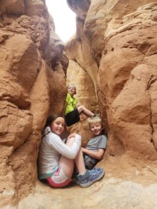
Tunnel Slot/Zebra Canyon
Details About the Hike
Location: Grand Staircase-Escalante National Monument
Distance: 5.2 miles (out and back)
Elevation gain: 300 feet (it’s a slightly uphill walk on the return hike)
Length of time: 3 to 4 hours
Difficulty: The trail to the slot canyon is easy; the slot canyon can be challenging
When to go: Anytime of year, although expect very high temperatures in the summer
Special Note: There is usually standing water in the slot canyon. This can be ankle to chest deep, depending on recent rainfall. Expect to get wet!
You will will come to a fork in the trail along a riverbed. If you go right, that will take you to the Tunnel Slot. If you go left, that will direct you to Zebra Canyon.
Getting to the Trailhead
The trailhead is located on Hole-in-the-Rock Road in Grand Staircase-Escalante National Monument.
In the town of Escalante, you can visit the BLM Visitor Center to get information on the hike and water levels inside of the canyon. They will give you brief instructions on how to hike to Zebra Slot Canyon, although we have more detailed instructions (with photos) below.
From Escalante, turn onto Hole-in-the-Rock Road and reset your odometer. Drive 7.8 miles down Hole-in-the-Rock Road to the third cattleguard. The car park will be on the right hand side of the road just past the third cattleguard.

Zebra Canyon
Hiking to Tunnel
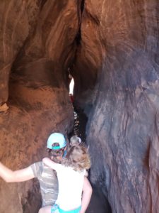
Tunnel Slot
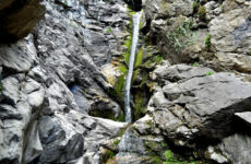
Upper Calf Creek Falls
Overview: We’ve been hiking in Escalante before and have done Lower Calf Creek several times. Upper Calf Creek is a shorter hike with some fun water activities that you can do at the end of the trail. Jumping off rocks into a waterfall and some wading pools. To the waterfall, the hike is downhill so the return is a little tough.
Start: Upper Calf Creek Falls Trailhead
Distance: 2 miles, round-trip
Approximate hiking time: 1 to 1.5 hours, round-trip
Difficulty: Moderate, Class 2 friction pitches just below the rim
Trail surface: Cairned slickrock route and boot-worn trails
Finding the trailhead: This unmarked spur road is located approximately 20.5 miles north of Escalante on UT 12 and approximately 7.4 miles southwest of Boulder. The dirt road to the trailhead can be found on the north (left) side of the road between mile markers 80 and 81. The very rough and rocky road leads 0.1 mile to the trailhead parking area on the rim of Calf Creek canyon. There are pullouts in which to park just off the highway if you are driving a low-clearance vehicle.
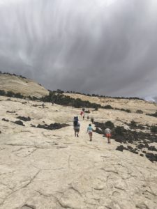
Trail to Upper Calf Creek Falls
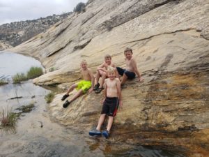
Wading Pool
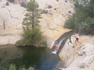
Waterfall Jump
Devil’s Garden
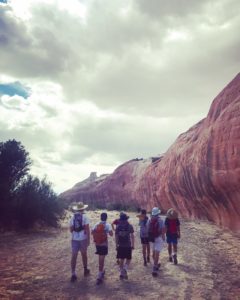
Overview: If you are not into longer hikes, then this is the stop you must make. You drive right up to the rock features and the kids will spend hours exploring. This is the spot that our kids wanted to return to. It’s easy to find and great place for adventure and entertainment.
Distance – 0.5 miles round trip
Approximate hiking time – 30 minutes to one hour
Elevation at Devil’s Garden – 5288 feet
Difficulty – Easy
Trail – Sand
Amount of water recommended – 1 liter
Bathrooms – Yes, located at trailhead
Season to hike – Can be hiked all year long
How to get there:
From Escalante, Utah, take the main road, Highway 12, east through Escalante. The road will head in a southeastern direction. Follow Hwy 12 for five miles, and as the highway makes a left curve, the unpaved Hole in the Rock Road will be on the right side of the road. If you were to go straight instead of take the curve that would turn into Hole in the Rock Road. From Torrey, UT, head south on Hwy 12 for nearly 60 miles. There should be a sign after a curve to the right that says Hole in the Rock Road. Turn left off of Hwy 12 here. From the turnoff onto Hole in the Rock Road would be a good spot to reset your trip odometer to 0. From here you will head southeast on the unpaved Hole in the Rock Road for approximately 12 miles (19 km). Turn right onto a dirt road with a sign for Devil’s Garden. This will take you to the trailhead.
Devil’s Garden
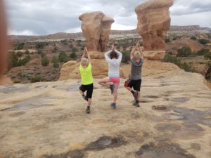
Cool Rock Features
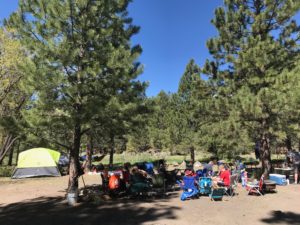
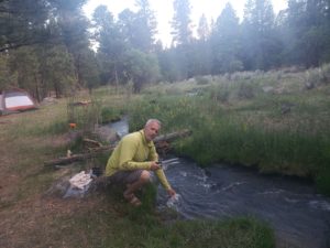
Great Camping Spot
Now, we’re not going to give away our exact camping spot but we will give you the vicinity since there are a lot of spots. This area is closer to Boulder than Escalante. What we like is that you are up in elevation so that temperatures are cooler, especially at night. You are surrounded by trees and streams. It takes about 20-30 minutes to get to the hikes in Escalante but we feel that it is worth it because of the experience. It’s along Forest Road 165 which can be accessed from Highway 12 near Boulder